


Anchor Alarm - SailGrib AA
توضیحات Anchor Alarm - SailGrib AA
Anchor Alarm توسط SailGrib ، یک برنامه هشدار لنگر کامل و مدرن است.
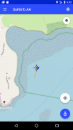
- برنامه را قبل از لنگر خود شروع کنید ، برنامه آهنگ شما را ضبط و ترسیم می کند.
- تلفن خود را روی جدول جدول بگذارید.
- مور بدون نگرانی در مورد برنامه.
- به برنامه برگردید. در مسیر ، نقطه مربوط به موقعیت قایق در زمان لنگر را پیدا کنید. به لطف حرکت معکوس پس از لنگر ، باید بتوانید آن را به راحتی روی نقشه تشخیص دهید.
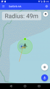
- با استفاده از علامت هدف در وسط صفحه ، نقشه را روی نقطه لنگر قرار دهید.
- دکمه آبی "Anchor" را فشار دهید تا موقعیت لنگر ثابت شود.
- با انتقال نقطه سبز به لبه منطقه ، شعاع منطقه خیس را تنظیم کنید.
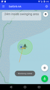
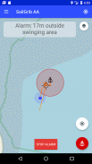
- با فشار دادن مجدد دکمه "Anchor" ناحیه خیس شدن را برطرف کنید ، سبز می شود. زنگ فعال است.
جدید: از نمودارهای قایقرانی Navionics خود در برنامه استفاده کنید!
با گزینه Premium:
- یک منطقه خیس شش ضلعی و قابل ویرایش بر روی صفحه نمایش تعریف کنید.
- هنگام بلند شدن زنگ هشدار ، نامه الکترونیکی ارسال کنید.
- مشاهده نقشه های SailGrib WR.
- اگر فراموش نکرده اید که برنامه را قبل از خیس کردن شروع کنید ، ردیابی GPX از SailGrib WR را وارد کنید.
این برنامه در پس زمینه اجرا می شود و از جدیدترین تکنیک های Android برای کاهش مصرف برق در حالی که حداکثر دقت موقعیت را دارد استفاده می کند.
توجه داشته باشید که صحت موقعیت شما به تلفن و موقعیت مکانی شما بستگی دارد. از مارس 2021 ، ما در نظر داریم که اکثر گوشی ها در دریا بین 2 تا 10 متر دقت دارند.
Anchor Alarm - SailGrib AA - نسخه 3.2
(06-10-2023)Anchor Alarm - SailGrib AA - اطلاعات APK
نسخه APK: 3.2حزمة: com.sailgrib.anchoralarmآخرین نسخه Anchor Alarm - SailGrib AA
سایر نسخهها


 3.55
3.55اپلیکیشنها در دسته مشابه


